
To scout drone locations before you arrive, use aerial mapping tools to get detailed visuals of the terrain and identify key features like obstacles and access points. Conduct terrain analysis to find flat, safe takeoff and landing zones, and plan your routes to avoid hazards like power lines or water bodies. Incorporate real-time weather data to adjust your plans and check for regulatory restrictions. If you want to discover more techniques, keep exploring this topic.
Key Takeaways
- Use aerial mapping tools to generate detailed site visuals and identify optimal drone launch points.
- Conduct terrain analysis to locate flat, accessible areas and avoid hazards like power lines or water bodies.
- Perform virtual site exploration and scenario testing with 3D models to plan safe flight paths.
- Assess weather and wind conditions using real-time data to adjust flight plans accordingly.
- Review regulatory restrictions and secure necessary permissions before arriving on site.

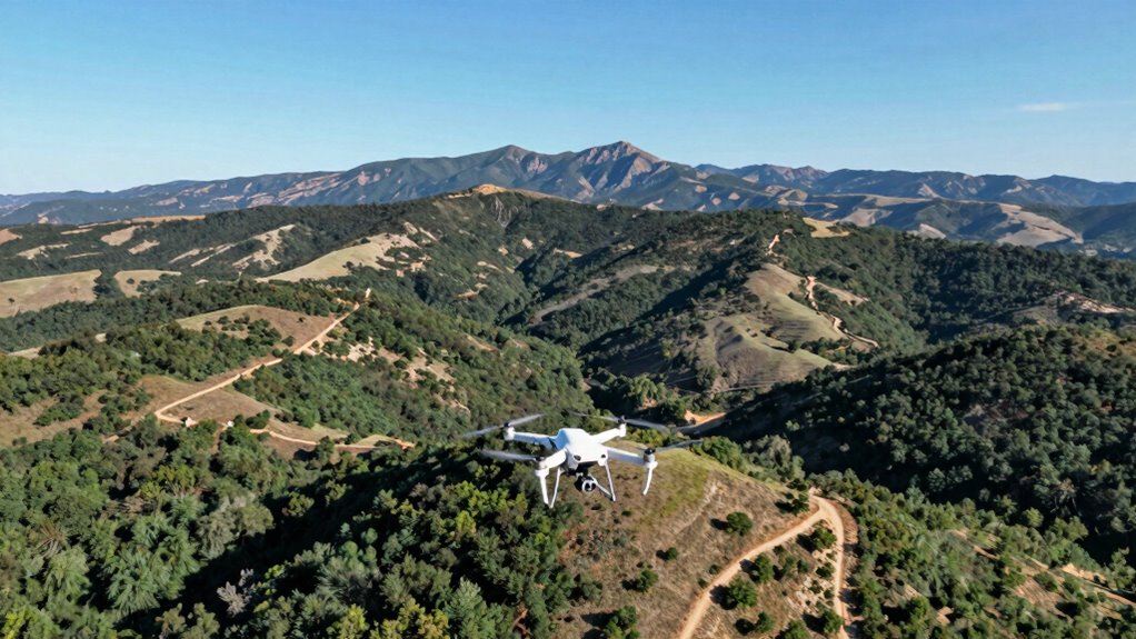
Ever wondered how to make your arrival smoother and more efficient? The key lies in thorough pre-visit planning, especially when it comes to scouting drone locations. Before you set foot on a new site, leveraging aerial mapping tools can give you a clear overview of the terrain and help you pinpoint ideal spots for drone operations. Aerial mapping provides detailed visuals that reveal elevation changes, obstacles, and access points, saving you time and reducing surprises once you’re onsite. By analyzing these maps, you can identify areas that offer the best vantage points, safe flight paths, and efficient coverage, all while minimizing risk. Incorporating terrain analysis into your planning process ensures that you’re prepared for any landscape challenges ahead. terrain analysis is equally critical. Understanding the landscape helps you anticipate challenges like uneven ground, dense vegetation, or restricted zones. When you review terrain data beforehand, you can decide where to establish takeoff and landing zones that are flat and accessible. It also allows you to plan flight routes that avoid hazards, such as power lines or water bodies, ensuring safer flights and higher-quality data collection. Combining aerial mapping with terrain analysis gives you a detailed picture, enabling you to adapt your drone setup and flight plans for maximum effectiveness. Additionally, utilizing aerial mapping and terrain analysis enhances your ability to comply with local regulations and identify potential hazards, which is vital for a smooth operation. Using online platforms and drone-specific software makes this process straightforward. Many tools let you upload geographic data, generate 3D models, and simulate flight paths. These features let you virtually explore the site, test different scenarios, and optimize your plans without physically being there. This approach not only reduces the amount of time spent on-site but also enhances safety and efficiency. When you arrive, you’ll already have a detailed, tailored plan, allowing you to execute your mission seamlessly. Moreover, understanding geographic features can help you assess environmental factors that might affect drone flights, such as wind patterns or weather conditions that vary with terrain. Incorporating real-time data can further improve your planning, allowing adjustments based on current conditions. A comprehensive pre-scouting process also includes evaluating regulatory restrictions, helping you avoid violations and ensure compliance from the start. Another advantage of pre-scouting with aerial mapping and terrain analysis is that you can identify potential regulatory restrictions or hazards. Some areas might have flight restrictions, or certain terrain features could pose risks to your equipment. Knowing these details in advance helps you prepare the necessary permissions or adjust your approach accordingly. Plus, it minimizes the likelihood of needing to make last-minute changes once on location, which can be costly and time-consuming.

Sky High Bull's-Eye (24"x24") Drone Ground Control Point GCP – UAV Aerial Target for Mapping & Surveying (6 Pack) | Center Passthrough (Black/White Markers) | Pix4D & DroneDeploy Compatible
24”x24” AERIAL TARGETS – Designed for low to medium altitude drone mapping and scanning, these drone GCPs were…
As an affiliate, we earn on qualifying purchases.
As an affiliate, we earn on qualifying purchases.
Frequently Asked Questions
How Far in Advance Should I Plan My Drone Scouting?
You should plan your drone scouting at least a week in advance. This gives you enough time for a thorough drone flight, checking the location from different angles, and evaluating potential obstacles. During this period, ensure your equipment maintenance is up to date, so your drone operates smoothly. Advanced planning helps you identify ideal spots, troubleshoot issues, and avoid last-minute surprises, guaranteeing a successful and efficient scouting mission.
What Tools Are Best for Virtual Drone Location Scouting?
For virtual drone location scouting, use tools like drone mapping software and platforms offering detailed satellite imagery. These tools enable you to perform virtual analysis, helping you identify ideal spots before arriving. Drone mapping creates accurate topographical models, while virtual analysis helps assess terrain, obstacles, and accessibility. This approach saves time, reduces risks, and allows you to plan your flight path more effectively, ensuring a smooth scouting process.
Can Weather Affect Drone Scouting Plans Significantly?
Weather impact can greatly influence your drone scouting plans, as poor conditions like strong winds, rain, or fog can hinder flight safety and reduce visibility. Always check the forecast before heading out, and be prepared to adjust your schedule if weather conditions threaten your drone’s safety or your ability to capture clear images. Prioritizing weather awareness helps guarantee successful scouting without risking damage or safety hazards.
Are There Legal Restrictions for Drone Scouting in Remote Areas?
Think of legal restrictions as invisible fences guiding your drone adventures. You must prioritize legal compliance and check permitting requirements before scouting in remote areas. Regulations vary by location, and ignoring them can lead to fines or confiscation. Always research local laws, obtain necessary permits, and respect privacy boundaries. Staying informed guarantees your drone exploration remains safe, legal, and rewarding, letting you explore remote terrains without unintended consequences.
How Do I Identify Potential Hazards During Virtual Scouting?
To identify potential hazards during virtual scouting, you should perform a thorough risk assessment by analyzing satellite images, maps, and available terrain data. Look for obstacles like power lines, tall trees, or unstable ground that could pose hazards. Use hazard identification techniques by noting areas with steep slopes, water bodies, or restricted zones. This proactive approach helps you anticipate risks, ensuring safer drone operations before you arrive on-site.

Newbeedrone Portable Drone Tool Kit Set: Come With Soldering Iron Storage Bag Prop Tool Screwdriver AIO Hex Driver Tweezers Cutter Solder Practice Board For FPV Drone FPV Starters RC Car Airplane
Muti-functional RC Tool Set: This highly integrated tool kit includes almost everything you need in the field, especially…
As an affiliate, we earn on qualifying purchases.
As an affiliate, we earn on qualifying purchases.
Conclusion
So, next time you think you’re ready to dive straight into drone scouting, remember—your best tool might just be a quick online map. Ironically, spending a little time beforehand can save you hours of frustration and fruitless searches. Instead of wandering aimlessly, you could be capturing stunning footage right away. It’s funny how a simple plan can turn “flying blind” into a smooth, successful mission. Don’t skip the prep—your drone (and your patience) will thank you.

DRONE PHOTOGRAMMETRY FOR REAL PROJECTS: MAPPING, SURVEYING, INSPECTION, AND 3D DATA WORKFLOWS
As an affiliate, we earn on qualifying purchases.
As an affiliate, we earn on qualifying purchases.

PLEGBLE Drones with Camera for Adults 4K, FPV Beginner Drone with One Key Take Off/Landing, Emergency Stop, Brushless Motor, 2 Batteries 30 Mins Flight Time, Under 249g, Toys Gifts for Teen Boys Kids
No Registration Needed – Weighing under 249g, this mini drone with camera does not require FAA registration or…
As an affiliate, we earn on qualifying purchases.
As an affiliate, we earn on qualifying purchases.