When you raise your drone’s altitude, it shifts the story your images tell from capturing tiny details to showcasing vast landscapes, changing how viewers perceive scale and purpose. A higher flight elevates the sense of grandeur, isolation, or connection, while lower shots focus on textures or expressions. Adjusting altitude affects mood, perspective, and focus, guiding emotional responses. Keep exploring, and you’ll discover more ways altitude can help craft compelling and meaningful drone stories.
Key Takeaways
- Higher altitudes reveal expansive landscapes, shifting focus from details to patterns and overall scene, creating a sense of scale and grandeur.
- Lower altitudes emphasize intricate textures and specific objects, fostering intimacy and detailed storytelling.
- Changing altitude influences lighting and shadows, affecting mood and emotional tone of the image.
- Elevated perspectives can evoke feelings of isolation or connectivity, shaping the narrative’s emotional impact.
- Adjusting altitude allows for strategic framing, highlighting either landscape breadth or detailed elements to enhance storytelling.
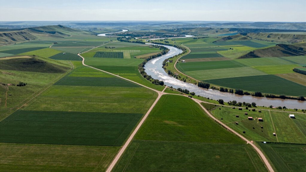
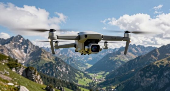
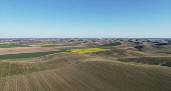
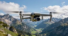
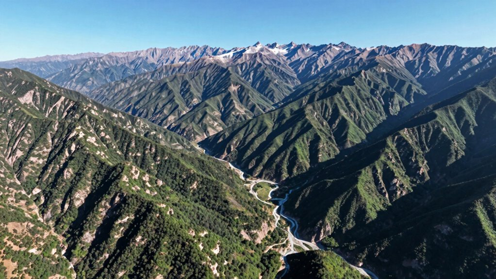
Have you ever wondered how altitude influences the quality and perspective of drone images? When you fly your drone higher, you’re not just changing the distance from your subject—you’re also altering the story your image tells. This shift is largely due to the aerial perspective that altitude creates. The higher you go, the more the scene below transforms from a detailed ground-level view into a broad, sweeping landscape. This isn’t just about capturing more area; it’s about changing the way viewers interpret what they see. As you ascend, the image’s focus shifts from individual details to overall patterns, shapes, and relationships. This perspective can evoke feelings of grandeur, isolation, or connectivity, depending on how you use altitude effects to frame your shot.
Altitude transforms your drone images from detailed close-ups to sweeping landscapes that tell powerful stories.
The effects of altitude aren’t purely aesthetic—they shape the narrative of your image. Lower altitudes let you capture intricate details, like textures, facial expressions, or small objects. These shots are intimate, providing viewers with a close-up story that emphasizes specific elements. On the other hand, increasing altitude gives you a more all-encompassing view, revealing relationships between larger features—such as the layout of a city, a field’s pattern, or mountain ranges. This sense of scale can communicate vastness, isolation, or interconnectedness, depending on your intent. The altitude effects determine whether your image feels personal or epic, detailed or expansive. Additionally, understanding the aerial perspective can help you better utilize altitude to influence mood and perception. Using the correct camera settings for different altitudes can ensure your images maintain clarity and detail, even from great heights. Recognizing how altitude impacts lighting conditions can further help you craft the desired atmosphere in your images.
Furthermore, higher altitudes can introduce challenges related to resolution and image clarity, especially if your camera settings aren’t optimized for distant shots. Also, consider how altitude influences light and shadows—higher altitudes can create sharper contrasts or softer, more diffuse lighting, which further impacts the mood and message of your shot.
Ultimately, altitude serves as a powerful tool in your drone photography arsenal. It allows you to shift perspectives, evoke specific emotions, and craft compelling stories through your images. By understanding the altitude effects and how they influence aerial perspective, you can better control the narrative your drone images tell. Whether you want to showcase intricate details or convey the vastness of a landscape, adjusting your altitude is your way to shape the story from above.

2K HD FPV Drone with Camera for Adults – Altitude Hold, One-Key Takeoff/Landing, 3 Speed Modes, Headless Mode, 2 Batteries, Foldable & Portable, Best Gifts for Beginners, Teen Boys & Girls
【2K Ultra HD Camera with Adjustable Angle】Capture stunning aerial footage with the 2K HD camera (90° remotely adjustable…
As an affiliate, we earn on qualifying purchases.
As an affiliate, we earn on qualifying purchases.
Frequently Asked Questions
How Does Altitude Affect Drone Image Resolution?
Higher altitudes generally decrease your drone image resolution because your camera captures a larger area, making details less sharp. To counteract this, you should adjust your camera settings, like increasing sharpness or resolution, and make sure image stabilization is active to reduce blurriness. Flying at lower altitudes can also improve resolution, but keep in mind the trade-off with coverage area. Balancing altitude and camera settings helps you get clearer, more detailed images.
What Is the Ideal Altitude for Capturing Specific Landscapes?
You should fly at an altitude of around 300 to 500 feet for capturing landscapes, as this range offers a balanced aerial perspective. Research shows that altitude variance within this range helps highlight terrain details without sacrificing resolution or context. This altitude allows you to showcase expansive views while maintaining clarity, making your images engaging and informative. Adjust slightly based on the landscape’s complexity and the level of detail you want to emphasize.
How Does Altitude Influence Drone Flight Safety?
Altitude greatly influences your drone flight safety, especially considering weather conditions and air traffic. Flying higher can expose your drone to stronger winds, reduced visibility, and unpredictable weather, increasing risks. Additionally, higher altitudes may bring you closer to manned aircraft, raising concerns about air traffic. To stay safe, you should always monitor weather updates, stay within legal altitude limits, and maintain awareness of nearby air traffic when adjusting your drone’s altitude.
Can Changing Altitude Improve Drone Image Composition?
Yes, changing altitude can considerably improve your drone image composition. By adjusting height variation, you create a dynamic aerial perspective that adds depth and interest. You can capture sweeping landscapes, emphasize focal points, and highlight patterns or textures. Using different altitudes allows you to experiment with framing, leading to more compelling and visually balanced photos. So, don’t hesitate to vary your height to enhance the storytelling power of your drone shots.
How Does Altitude Impact Drone Battery Life During Flights?
Higher altitudes can decrease your drone’s battery efficiency because the motor works harder to maintain altitude and stability. Proper altitude management helps conserve battery life, allowing longer flights. When you fly at lower altitudes, your drone uses less power, extending session durations. Keep an eye on altitude changes, and adjust accordingly to optimize battery usage, ensuring you capture the shots you need without risking unexpected power loss.

GPS Drone with 4K Camera for Adults, Foldable RC Quadcopter with 1312ft Range Video Transmission, 48 Mins Flight Time, Auto Return, Follow Me, Circle Fly, Waypoint Fly, Gesture Control
【GPS Technology Safety and Reliability】GPS Drones are equipped with advanced flight control systems and GPS technology to ensure…
As an affiliate, we earn on qualifying purchases.
As an affiliate, we earn on qualifying purchases.
Conclusion
As you elevate your drone, you unlock new perspectives that transform your images. At higher altitudes, you can capture up to 80% more of the landscape, revealing patterns and details unseen from the ground. This shift not only enriches your storytelling but also emphasizes the importance of altitude in framing your shot. So next time you fly, remember: changing altitude isn’t just about height — it’s about shaping the story your drone tells.
GPS Drone with 4K Camera for Adults, Foldable RC Quadcopter with 1312ft Range Video Transmission, 48 Mins Flight Time, Auto Return, Follow Me, Circle Fly, Waypoint Fly, Gesture Control
【GPS Technology Safety and Reliability】GPS Drones are equipped with advanced flight control systems and GPS technology to ensure…
As an affiliate, we earn on qualifying purchases.
As an affiliate, we earn on qualifying purchases.